

Introduction
In the world of drones the seamless integration of technology plays a crucial role in their impressive capabilities. A key component that drives the precision and autonomy of drones is their GPS system.
Exploring “How Does Drone GPS Work” reveals the satellite based navigation web that empowers these flying machines. This article delves into the workings of drone GPS shedding light on the technology that guides drones through the skies and enables new frontiers of exploration and innovation.
From satellite communication, to real time positioning this exploration aims to demystify the complexities providing an understanding of the mechanisms that contribute to the capabilities of drone navigation systems. Come along as we take a journey through the skyways and uncover the technology behind GPS that propels drones, to heights.
The Mechanics and Components of GPS Drones
Understanding the GPS technology on drones:
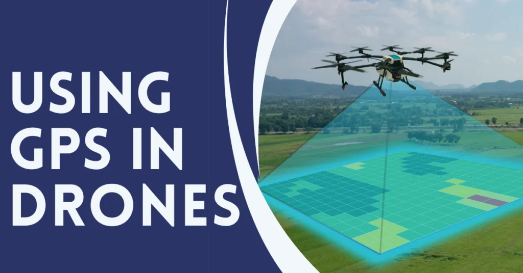
Fundamentally, A GPS drone consists of a network of at least thirty satellites in order to envelop the earth. The GPS receivers that come with drones or other gadgets usually get continuous signals from these satellites hence they can locate themselves at any given time. Adding to this, the inclusion of GPS means that drones can also determine their own relation with the ground. The ability to maintain steady positioning or controlled flight paths for most of the aforementioned operations is necessary.
Parts which are crucial for a GPS drone operation
GPS Module:
It is this antenna that receives these signals from the GPS satellites. It is a pilot giving you instant information on the location, height of your drone, and its speed at any particular moment.
Flight Controller:
The core of the drone is a flight controller which processes the information generated by sensors and GPS units. It maintains the balance of the drone in order to control the movements towards its set flight line.
Sensors and Gyroscope:
Generally speaking, apart from the built in a GPS module, most of the drones will have a host of other sensors like the accelerometer and gyroscope. They make the drone balanced and moving smoothly without hitting obstacles or other objects.
Communication System:
These units comprise of the transmitters and receivers that enable the drone to communicate with the remote controller or smart phone app. At times here, the GPS assists on functions like “retro back home” or “follow me”.
How Does Drone GPS Work
If a GPS drone is switched on, it first tries to detect the signals of the closest GPS satellites. When it can no longer distinguish additional satellites, it carries out a precise localization by using triangulation technique. The information is up-to-date and constantly fed into the flight controller for the purpose of providing continual adjustment to drone’s motors and propellers so as to ensure stable flight and accurate navigation.
The advent of GPS has brought a lot of changes in the issue of flight control using drones. For example, in ‘return to home’ mode, a drone can take itself back to the place where it was launched, using positional coordinates of the points visited during this flight as reference. ‘Follow-me’ mode is similar in that a drone can track positions relative to an object’s continuously updated GPS location.
The Integration of GPS with Other Technologies:
Today’s drones commonly incorporate GPS together with a variety of devices including Visual Recognition System and thermal imagers. In addition, this integrates improves the drone’s situational awareness and operations. For instance, though GPS shows locations, more focused operations such as landing on an unsteady platform could require more visual-oriented systems.
However, it has made drones more dependable, flexible and efficient as they can handle sophisticated tasks. It is because of the GPS system that drones have transformed from ordinary remote controlled air crafts to full-fledged robotic flying machines for stabilization and precision in flight to providing advanced functions such as autonomous navigation. So, as we go further exploring these machines, clearly the GPS technological development would always be one of them.
Comparing GPS and Non-GPS Drones
There exists huge variety in the world of drones – right from simple no GPS machines to sophisticated models incorporating GPS. As both drone enthusiasts and professionals, it is important to understand the differences between these two types. The following part looks into the comparison between GPS and non-GPS drones considering their differences, abilities, as well as scenarios they best be used in.
Key Differences Between GPS and Non-GPS Drones
Navigation and Stability:
GPS Drones: Such, these drones make use of satellite signals. This enables pinpoint positioning and this precision is crucial for tasks like aerial surveillance or photography. GPS also allows for other sophisticated functions such as automated flight missions, automated way-backs, and stable flights amidst windy skies.
Non-GPS Drones: These unmanned drones do not have GPS and therefore are controlled manually. Due to their tendency towards drifting, they might also find it difficult to stay upright, particularly on windy days. They are generally restricted to pleasure or non-precision navigation.
Flight Capabilities and Features:
GPS Drones: These intelligent flight modes include waypoint navigation, follow-me modes, and auto return home on signal loss or low battery. These features improve drones’ capabilities thus suitable in filmmaking, search and rescue missions and many others.
Non-GPS Drones: The drones normally feature simple flight options. They better suit man-flying experiences that may be used in hobby work or practice of a beginner. Moreover, their simplicity creates a convenient opportunity for people who are just getting started with the basics of drone piloting.
Cost and Accessibility:
GPS Drones: Due to the inclusion of GPS, these drones are normally more expensive. Professionals or hobbyists that want extra features and stability prefer them.
Non-GPS Drones: These days, most cheap non-GPS drones are preferred by the newcomers and people who do not want to spend much money. The come as affordably priced alternatives to some more expensive and feature-filled drones with GPS functionality.
Use Cases and Applications:
GPS Drones: GPS drones that are ideal for commercial apps have many uses in agriculture, realtor, movies production or industry inspecting. Therefore, they are vital in many professional tasks due to their capability of flying predetermined routes as well as hovering precisely.
Non-GPS Drones: These drones are primarily meant for recreation and can be convenient for improving one’s flying techniques, casual photography, or playing around indoors. The simplicity and affordability also make them simple for many people to access.
Choosing the Right Drone:
A user has to choose among a GPS versus Non-GPS drone based on their need, pocket size and experience. A GPS drone is most appropriate for precise, stable and advance navigation tasks. On the other hand, a novice is still new in the world of pilot and thus; it would be preferable to use non-GPS drone.
There is no denying that a number of professionals consider GPS drones to be advanced and a must have while there are cheap drones for newbies. Each is meant for a particular role it plays in covering specific categories of users and systems respectively. This knowledge enables people as well as institutions, while making investment in drone related technologies.
Advantages and Limitations of GPS in Drones
The combination of GPS technology with drones has transformed these tools into highly advanced, practical, and productive resources. Nonetheless, as any other technology, it has both positive and negative aspects. Enlightening such will assist users to derive maximum benefits out of their drones whether for hobbies, profession or experimental reasons.
Advantages of Using GPS in Drones
Enhanced Stability and Precision:
GPS technology greatly improves the drone’s ability to hold in a consistent hover, and navigate with precision. Accuracy is very important in applications such as aerial photography, surveying, and mapping.
Advanced Flight Features:
The most sophisticated drone option that includes autonomous flight, waypoints, and Geofences is equipped with GPS. Such characteristics enable programmable trails and return home functions, ideal for complicated tasks.
Improved Safety:
Safety is improved during operation because as soon as signal gets lost, the drone should be able to return to home without any additional commands by the pilot. The fact offers reduced risk of lost drone as well as safe flight under different conditions.
Better Tracking and Management:
The GPS helps to track multiple moving drones for fleet operations and commercial purposes. It is especially crucial for sectors such as agriculture, search and rescue, and logistics.
Limitations of GPS in Drones
Dependency on Satellite Signals:
Obstructions in environments like dense urban areas or thick forests can interfere with the signals from satellites that GPS drones rely on. As a result the accuracy of the GPS may decrease or in some cases the drone may completely lose its GPS functionality.
Increased Complexity and Cost:
Integrating GPS into drones adds complexity to their design and operation which can lead to costs in terms of both purchase and maintenance.
Vulnerability to Interference and Jamming:
GPS signals are vulnerable to interference from sources such as buildings certain weather conditions and deliberate jamming. This creates challenges in ensuring reliable operation.
Higher Power Consumption:
Operating a GPS module requires power, which can reduce the flight time of the drone. This is particularly important to consider for missions that require flight durations.
Balancing the Advantages and Limitations
To strike a balance between the advantages and limitations of using GPS in drones users should take factors into account.
Environment:
It’s important to choose a drone that’s suitable for the specific operational environment. For example in areas where there is a potential, for GPS signal loss it may be wise to have navigation systems in place.
Skill Level:
Having an understanding and training, in the aspects of operating GPS drones especially for commercial or specialized purposes.
Preparation:
Consistently updating the GPS firmware and performing flight checks to ensure optimal performance and minimize any potential risks related to signal interference or jamming.
The use of GPS technology has undoubtedly improved the performance of drones making them more accurate, adaptable and secure. Nevertheless it is crucial to recognize and accept the constraints associated with this technology. By doing drone pilots can effectively utilize GPS enabled drones to harness their benefits while mitigating any disadvantages.
Considerations for Purchasing and Using GPS Drones
When it comes to buying and using GPS drones there are a few factors that potential buyers and operators should remember. These factors will help guarantee that you choose the drone for your requirements and take full advantage of its GPS capabilities.
Purpose and Intended Use:
If you intend to utilize the drone for business related tasks such, as capturing photographs, conducting surveys or performing inspections it is recommended to invest in a top notch GPS drone that comes equipped with features. These drones ensure navigation and stability what’re crucial for professional applications.
Recreational Use:
For recreational flying and hobbyist purposes, a more budget-friendly GPS drone may suffice. While they may lack some advanced features, they provide an excellent entry point for learning and enjoyment.
Budget Considerations:
There is a range of prices, for GPS drones. It’s important to decide on your budget and look for drones that fall within that price range. Remember, priced models generally have construction quality, more advanced features and longer flying durations.
GPS Accuracy and Features:
Make sure to evaluate the GPS precision of the drone you are interested, in. Take note of features such as GPS assisted hovering return, to home capabilities and waypoint navigation to see if they meet your needs. These functionalities can significantly improve the drones ease of use.
Camera Quality:
If photography or videography is part of your plan, pay attention to the camera specifications. Ensure it meets your image or video quality requirements. Some GPS drones come with integrated gimbals for stabilized footage.
Battery Life:
When using a drone it’s important to take into account the battery life as it directly affects how time you can spend flying before having to recharge. Having flight times is particularly advantageous especially when it comes to use cases.
Range and Signal Strength:
Evaluate the drone’s control range and signal strength. A longer range allows for more extensive exploration, but be aware of local regulations that may limit how far you can fly.
Regulations and Licensing:
Familiarize yourself with the local and national regulations governing drone usage. In many countries, drones above a certain weight or intended for commercial use require licensing or registration.
Maintenance and Support:
Check the availability of spare parts and the manufacturer’s reputation for customer support. Having access to replacement parts and responsive customer service can be crucial if the drone requires maintenance or repairs.
Training and Skill Level:
Evaluate your level of skill. Identify any areas where additional training may be beneficial. If you are a beginner, in operating drones it is advisable to consider enrolling in a training program that can help improve your piloting abilities particularly if you intend to utilize the drone for purposes.
Conclusion
In conclusion the realm of GPS drones is truly fascinating filled with innovation and opportunities, for exploration. We have delved into the mechanics of GPS technology in drones compared models with and without GPS capabilities examined the advantages and limitations of integrating GPS and discussed considerations when purchasing and using GPS drones. It is evident that these aerial devices hold potential. Whether you are a seeking results in your work an adventure seeking hobbyist or someone keen on embracing the latest technological marvels GPS drones have something valuable to offer.
By relying on GPS technology as their guiding star drones have evolved from gadgets into tools used across various industries such as agriculture and filmmaking. They bring stability, accuracy and versatility to exploration. However it is important to approach these drones with an understanding of their capabilities and limitations while maximizing their features.
As you embark on your journey with GPS drones remember to select a drone that aligns with your goals and budget. Stay informed, about regulations governing drone usage consider investing in training if necessary and prioritize safety by flying
GPS drones have revolutionized the way we capture breathtaking views carry out inspections and experience the exhilaration of flying. They have expanded our horizons. Removed any boundaries that previously existed in the sky.
2 Comments on “How Does Drone GPS Work – Best Insight Digital Innovation”